
July 2016
Kungsleden, Sweden
05
Kungsleden - directly translated as 'the King's Way' but now referred to as 'the Royal Way' in English - is Sweden's best-known long-distance hike. Passing some of Scandinavia's most dramatic scenery, including Kebnekaise - Sweden's highest mountain - and the vast wilderness area of Sarek National Park, the trail covers 440km and takes a month to complete in its entirety. Most of it also falls within the Arctic Circle and therefore offers the opportunity to experience 24-hour sunlight during the month of July.

My original plan had been to hike the northern half, from Abisko to Kvikkjokk. Unfortunately I had to return to the UK early for personal reasons and was therefore only able to complete the first stage until Vakkotavare. I have promised myself that one day I will return to hike the second stage, including to explore the mountain and glacier world of Sarek. Until then, I have memories of the north: a stunning landscape of immense valleys, endless panoramas, peaceful mountains and some of most unforgettable hiking I have ever done.
Apart from the incredible scenery, there are other reasons to recommend Kungsleden: the trail is well-marked, the hut infrastructure is second to none, the people are friendly (and speak perfect English) and - for me a major draw - wild camping is legal almost anywhere. The route itself is generally quite flat and non-technical but there are plenty of possible detours which offer more challenging walks and the opportunity to summit one of the innumerable fells: it is therefore suitable for people of different abilities and experience. The trail can become busy in peak season (late July and August) but outside of this period it is uncrowded, and real solitude is possible if you detour from the main route. Yes, Scandinavia is expensive and in July the mosquitoes and midges are a real nuisance, but these issues can be managed with some careful planning and are easily forgotten when enjoying such a beautiful and pristine part of the world.

Practicalities:
Kungsleden can be broken into 5 stages, accessed by public transport at the following points (from North to south): Abisko, Nikkaluokta, Vakkotavare, Saltoluokta, Kvikkjokk, Jäkkvik, Ammarnäs and Hemavan.
The northern section of the trail is the most popular and contains some of the most iconic scenery. This part can either be completed from Abisko to Nikkaluokta (passing Kebnekaise) or from Abisko to Vakkotavare. Either route takes about a week and most people hike from north to south. I had two weeks and hiked to Vakkotavare, including numerous detours and summiting Kebnekaise.
In terms of this northern section of the trail, the main transport hubs are Abisko, Kiruna and Gällivare. I caught a budget flight to Stockholm from London (2.5 hours) and then took the overnight Arctic Express train to Abisko (20 hours). From Vakkotavare I caught a bus to Gällivare (3 hours), where I took another bus to Kiruna (1.5 hours). From Kiruna I caught a domestic flight to Stockholm (1.5 hours) to connect with my return flight to London. Yes, my return trip was fairly convoluted as I had not appreciated at the time of booking that I could have flown from Gällivare. Noted for next time! It is, of course, possible to take the train or fly in either direction.

There are a number of huts along the trail which are well equipped and managed. If you do not wish to camp and prefer to travel light you could stay at the huts - beds cannot be booked but even in peak season they apparently guarantee everyone a space, even if on the floor. Alternatively, you can pay to camp next to the huts and use their facilities: each has stoves you can use to cook. If you camp wild you can buy camping gas from any of the fell stations (I stocked up at Abisko).
During the first stage, the following huts have shops where you can buy food and provisions: Abisko, Abiskojaure, Alesjaure, Sälka, Kebnekaise Fellstation, Nikkaluokta, Kaitumjaure and Vakkotavare. I would recommend taking as much food as you can with you, however, as it quickly becomes very expensive if you rely on the huts for food. Some of the huts even have saunas, which are very inviting after a day trudging through cold rain. I chose to camp wild for the entire trip, with the exception of Abiskojaure after an afternnon of bad weather.
Speaking of which, due to the northern latitude and mountainous location you have to be prepared for all weather conditions. You will almost inevitably encounter rain - a good rain jacket and bag cover are therefore essential - and the temperatures can become fairly cold even in mid-summer. I bought a pair of gloves last minute at Abisko and they turned out to be crucial. In fact, I would not have been able to hike Kebnekaise (which I did overnight) without them because of the bitterly cold winds for most of the hike up. Toward the summit I actually ended up wearing every item of clothing I had. I also met a girl coming from the south who was hiking the whole trail (from Hemavan) and she had camped in snowfall just a week before. Equally, I experienced plenty of sunshine and a couple of very warm days. So really, be prepared for anything.

Long-sleeved tops and trousers - as well as mosquito spray - are also essential in July due to the mosquitoes and midges, who come out in force when the winds die down. On many evenings I had to concede defeat and retreat to my tent. Anyone who has hiked in Scotland in summer will know the score.
In terms of water, there are rivers and streams everywhere so there is no problem in finding somewhere to fill up. I generally only had to carry a litre at a time as I could easily find water when I needed, which helped to keep my backpack light. A word of caution, however: while I only used purification tablets half the time and never had a problem with the water, in Kiruna I met a Danish guy who had had to be airlifted to hospital with extreme stomach pain and dehydration, potentially caused by drinking bad water. His case is obviously an extreme exception and most people never experience a problem, but best to play it safe and take purification tablets.
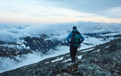
The condition of the trail varies. The main path is relatively flat and easy-going but the ground can often be boggy and you will become very familiar with the wooden planks that are laid out in particularly marshy spots. There are a number of neat suspension bridges to cross the numerous rivers, as well as countless streams you have to step-stone. You also have to wade across a couple of shallow rivers, which adds a bit to the adventure. I would certainly recommend incorporating a couple of fell summits for some astounding views - there are many to choose from near the trail. Reaching the summit of Kebnekaise, in particular, was an incredible experience and a moment I will never forget. I teamed up with a German guy and we took on the mountain overnight, leaving camp at 7pm, timing the summit for midnight and returning back at around 4am. It was an exhausting, exhilarating and unique hike that really took advantage of the 24-hour daylight.

There is only one guide book in English, by Claes Grundsten. You could get by with just using the book if you are sticking to the main trail but I invested in a map, which was essential for planning detours. Lantmäteriet map BD6 covers the area from Abisko down to Singi (including the Kebnekaise massif and Nikkaluokta to the east). BD8 covers the sections from Singi to Vakkotavare but as the maps are expensive I made do without one for the last few stages.
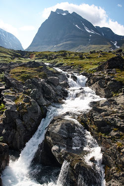
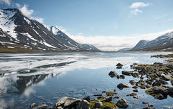
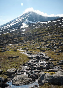
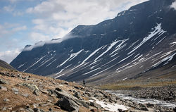
In terms of the best scenery, that is a difficult question to answer because each day had its own offering of stunning vistas. I took a detour south of Alesjaure into the valleys of Visttasvággi and Stuor Reaiddávággi on the recommendation of a blog, and I would certainly recommend the same (see photos below). Both valleys are stunning and the section at the Nallo hut is one of the most beautiful places I have ever been. Darfáljávri was also an unforgettable camping spot.

Route:
Below is an overview of my hike. Detours from the main route are marked in italics. These include the detour into Visttasvággi and Stuor Reaiddávággi, the 'loop' of the Kebnekaise massif by way of Darfáljávri and the pass into Guobirvággi, and two fell summits within easy reach of the trail - Stuor Jierta and Sanjarcohkka. If you are looking to just complete the main route from Abisko to Vakkotavare, this can be done in 5/6 days. If you wanted to include Kenekaise you would need to add another 2/3 days, depending on whether you were finishing at Nikkaluokta or continuing south. In terms of places to stop, I generally camped within sight of the huts but not next to them.
Day 1: Abisko to Abiskojaure (8 miles, 4 hours)
Day 2: Abiskojaure to Alesjaure (13.5 miles, 8 hours)
Day 3: Alesjaure to Vistas (11 miles, 7 hours)
Day 4: Vistas to Sälka (15 miles, 10 hours)
Day 5: Sälka to Kebnekaise (15.5 miles, 10.5 hours)
Day 6: Kebnekaise summit (11 miles return, 9 hours)
Day 7: Kebnekaise to Darfáljávri (5 miles, 4 hours)
Day 8: Darfáljávri to Singi via Guobirvággi (10 miles, 7.5 hours)
Day 9: Singi to Kaitumjaure, including Stuor Jierta summit (11 miles, 8 hours)
Day 10: Sanjarcohkka summit (3.7 miles return, 4 hours)
Day 11: Kaitumjaure to Teusajaure (8 miles, 6 hours)
Day 12: Teusajaure to Vakkotavare (6.5 miles, 3.5 hours)


 |
|---|
Láddjuvággi with the peaks of Singićohka (centre) and Duolbagorni (right)
 |
|---|
Stuor Reaiddávággi with the peak of Nállu centre
 |
|---|
The intersection of Stuor Reaiddávággi (left) and Visttasvággi (right)
 |
|---|
The western end of Stuor Reaiddávággi
 |
|---|
Stuor Reaiddávággi and the Nallo huts
 |
|---|
Tjäktjavagge from the hill by Dalsjön with the Singi huts visible just left of centre
 |  |  |
|---|---|---|
 |  |  |
 |  |  |
 |  |  |
 |  |  |
 |  |  |
 |  |  |
 |  |  |
 |  |  |
 |  |  |
 |  |  |
 |  |  |
 |  |  |
 |  |  |
 |  |  |
 |  |  |
 |  |  |
 |  |  |
 |  |  |
 |  |  |