March 2016
GR221, Mallorca
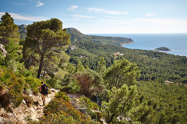
The GR221 runs the length of the Serra de Tramuntana, the mountain range that lies along the northwest backbone of the island of Mallorca, notching up 92.5 miles or so in total. I was unaware that Mallorca offered hiking possibilities, let alone a long-distance path, until I started researching places that would be suitable (i.e. warm) for hiking early in the season. Being in the Mediterranean and mountainous - at least on the north side - Mallorca is in fact the perfect place for hiking in March.
The mountains are fairly gentle - the highest peak, Puig Major, is 1445m (and unfortunately inaccessible to the public) - but the real appeal is the proximity to the sea. For most of the GR221, the wide expanse of the Mediterranean offers a stunning backdrop to undulating hills and rocky outcrops; at times you can see both the north and south coasts simultaneously. The most memorable section of the trail is between Valldemossa and Deia. Here the path follows the edge of a steep drop-off: you feel as if you are walking on the crest of the island.

Practicalities:
Getting to and from the trailheads was straightforward. I took a Ryanair flight from London to Palma, arriving the Saturday evening, and after meeting my hiking companion the following morning on Easter Sunday at the central bus station in the city, took a direct bus to Port d’Andratx. The journey took around 1 hour. Getting a bus from Pollença back to Palma was equally easy and took around 1.5 hours.
The trail is not entirely finished or serviced, which actually added to its charm. A guidebook or map is definitely required as some sections of the trail are not sign posted. It’s also useful to make sure your information is as up to date as possible because a couple of sections are ‘closed’ and you must choose which work-around to take. My guidebook suggested a fair amount of road-walking on day 2 but in fact it is quite possible to follow an alternative route to the north past a large estate building called the Planîcia.
There are a number of refuges, but none on the initial 3/4 stages. Apparently they have to be booked in advance; you cannot simply turn up and hope for a bed. There is also only one campsite, in Lluc, which I did not see. We chose to hike with food and tents, camping in the wild. There were plenty of good spots. In fact, the mirador at La Trapa (a former monastery) was one of the best places I have ever slept - the view across to the island of Dragonera is stunning. Walking the trail and sleeping in hotels in the mountain towns would also be very easy and pleasant way to enjoy the journey: perfect pit stops to enjoy a drink and tapas after a long day's walk.
In terms of the weather, after 5 days of beautiful sunshine and cool breeze the rain did arrive and the temperature really dropped. As always with hiking, you have to be prepared for the worst, even on an island which reportedly has 300 days of sunshine a year. The anticipated showers turned out in fact to be torrential rain and the final stretch to Pollença was a hard slog, although we were grateful the weather had at least held up until the last day. In the final couple of hours, my friend and I cast a sorry picture walking along the MA10, being showered with water each time a car or truck passed us at speed. At one point a passing motorist slowed down next to me. Expecting him to perhaps offer a lift into town (which I would have refused, of course) or even just a friendly query to ask if I was alright, the driver told me that I should be walking on the other side of the road, facing toward the traffic, before driving away. It was not the most welcome of advice. By the time we arrived in the town, a warm coffee and a tall beer were very welcome.
The other thing to mention about hiking the GR221, as contradictory as it sounds after the last paragraph, is the apparent lack of water on the island: the towns were pretty much the only places to fill up as the riverbeds were generally dry and the springs were few and far between. This was not overly problematic but did mean we were carrying 3 litres each at times.

Itinerary:
The route is split into 8 or 9 stages. We only had 6 days, which meant some fairly long days of walking. We would generally finish in a town for a drink and then hike an hour or so further to find a camping spot out of town. The distances do not seem that long on paper, but don't underestimate how long each section will take you - the timings in our respective guidebooks were usually quite accurate, unlike the timings given on the sign posts.
Day 1: Port d’Andratx to La Trapa (7 miles, 5 hours)
Day 2: La Trapa to Estellencs (15 miles, 10 hours)
Day 3: Estellencs to Valldemossa (17 miles, 9 hours)
Day 4: Valldemossa to Soller (16 miles, 9 hours)
Day 5: Soller to Lluc (17 miles, 8 hours)
Day 6: Lluc to Pollença (11 miles, 4.5 hours)
Every section of the trail would be accessible as a day hike as the trail passes numerous towns and road. A hike from Valldemossa or Deia up to and along the ridge would be a fantastic day hike and with a number of trails in the area there are several possibly itineraries you could put together.
It was in fact in this section, between Valldemossa and Soller, that we took our main detour from the GR221. Instead of leaving the cliff-edge path and dropping into the valley to reach Deia we continued on the high ground, against the advice of my guidebook. After entering mountain-top farmland, the path continues on to three gentle peaks before making a long and steep decent to Soller through a quiet wooded valley. While the route was the most memorable and scenic part of our entire trip, it was very tough under foot and we became lost on at least two occasions. Only recommended if you have plenty of energy and a good map.

04