
August 2017
The Kaçkars, Turkey
08
The Kaçkar mountains, an extension of the Caucasus, rise above the Black Sea coast in north-eastern Turkey. The area is said to be one of the most bio-diverse in the world, with large areas of mature evergreen forest, glacial lakes, a spectacular variety of flowers and abundant bird-life. The region offers some of the best hiking in Turkey and - given its popularity with international tourists has taken a marked downturn in recent years - something a little off the beaten track. What's more, aside from hiking, the region is also of significant cultural interest, with an ethnically mixed population (Turkish, Hemşin and Laz being spoken by the locals), picturesque yalas (mountain villages) and beautiful stone monastery churches and castles (built by the Armenians and Georgians) scattered over the hillsides and a number of local traditions - such as bull fighting and bee keeping - on display.

Practicalities:
The Kaçkars can be accessed from either Trabzon, a coastal city a few hours from the northern part of the mountain range, or Erzurum, which is the better option for the southern routes. Both cities have airports, plenty of accommodation and bus connections to the mountains.
I took a flight to Istanbul and a domestic connecting flight to Trabzon, from where we took a bus to the picturesque town of Yusufeli which lies east of the mountain range (around 4/5 hours) and then a second small bus to the village of Barhal (around 1 hour). From Trabzon you need a full day to reach Barhal. The return journey, from the west side of the mountains, was shorter and more straightforward - we took a taxi from Çamlihemşin to Ardeşen (roughly 30 minutes) from where we took a bus to Trabzon airport (around 2 hours).
There is plenty of inexpensive accommodation in Trabzon and in the larger villages. In Barhal we stayed in Karahan pansiyon and in Avesor we stayed in the hikers pansiyon just outside of the town. Both were comfortable and provided great food (dinner and breakfast).
There are a number of campsites marked on the map but which are in reality not much more than a good area to pitch, although some may have a water source and/or a toilet. Otherwise, there are plenty of great spots for wild camping - our night by the mountain lake of Libler Gölüm was particularly memorable. There are no mountains huts but there are some farm huts scattered over the mountain sides and plains which are generally unlocked and can be used as shelter.
English is not widely spoken in the region so you will need to know a little Turkish (or, as in my case, travel with a Turkish-speaker). Finally, it is possible to hire mules and drivers to carry baggage for extended hikes. While the locals are not generally big fans of the British or Americans, they are very friendly and happy to provide assistance if you need it.

We had good weather on the trip, which was generally sunny, hot and with clear skies. Cloud and mist tends to build up over the mountains in the afternoon, in particular on the west side of the range, which is practically blanketed in clouds from mid-August. Most hikers seem to pass through in July and early August. There are plenty of rivers and streams to fill up on water, which you will need to do quite regularly given the fairly high temperatures.
In terms of paths, the state of the paths is variable and they are not that well maintained. There are no way-marks and few cairns; equally, the path can often disappear and reappear and can be hard to follow.
At the same time, it is not possible to buy any official maps of the area (as topographical information is considered a state secret). There is only one guide book on hiking in the Kaçkars, written by Kate Chow. While the information she provides about itineraries, practicalities and the region is really useful, the description of the trails can be confusing and the map which comes with the book is not overly detailed.
As a result, having GPS (either on your phone or a GPS device) is essential. We used Wikiloc on an iPhone and followed a number of different routes plotted by hikers. Make sure you take an extra battery for charging as you may spend a night or two away from villages and electricity.
Finally, don't be alarmed by the sound of gun shots or bangs, which you may hear quite frequently in the hills - it is usually just the locals letting off bangers or gun shots to scare away any bears which may be nearby. Indeed, carrying a few bangers to set off when you pitch your tent and before you go to sleep is a good idea.

Itinerary:
We hiked from Barhal to Ayder over 4 days, crossing the range at the Kirmiza Geçiti pass (3,100 metres), being the most northerly crossing of the Kaçkars. Barhal is a lovely place to start a trek, but Ayder is quite overrun with tourists (mainly from Turkey and the Gulf) and presents quite a shock if you are arriving from the tranquility of the mountains. We did, however, visit the hot springs in the town, which was a great way to relax and clean after several days on the trail, before catching a bus to the less busy town of Çamlihemşin.
At the start of our trek, we arrived in Barhal quite late in the day and stayed the night in a pansiyon. We wild camped for the next two nights, at Satibe campsite (positioned on a bare ridge with wonderful views into two valleys) and at the extremely beautiful high-altitude lake of Libler Gölüm, which sits below the Kirmiza Geçiti pass. The Kirmiza Geçiti pass offers fantastic views both east and west and, toward Avesor, I would highly recommend taking a detour for an hour or so to visit the sublime lake of Büyük Gölüm. That night we stayed at the hikers pansiyon just outside Avusor.
Day 1: Barhal to Satibe campsite via Karagöl lake (8 hours)
Day 2: Satibe campsite to Libler Gölüm via Pişenkaya (8 hours)
Day 3: Libler Gölüm to Avusor via Kirmiza Geçiti pass and Büyük Gölüm (7 hours)
Day 4: Avusor to Ayder via Hyder (6.5 hours)
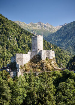
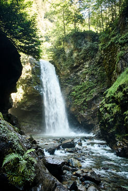
From Ayder we caught a bus to Çamlihemşin, which sits in a lush forrested valley further to the west, and spent the next day visiting Palovit water falls and the impressive Zil kale castle.
 |
|---|
View north from the ridge at Satibe campsite.
 |
|---|
Descending from Kirmiza Geçiti pass toward Avesor.
 |
|---|
The view east toward Pişenkaya, en route to Libler Gölüm.
 |
|---|
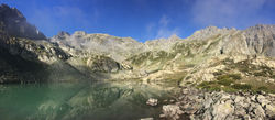
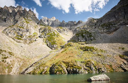
Libler Gölüm, below Kirmiza Geçiti pass.
 |
|---|
Libler Gölüm, below Kirmiza Geçiti pass.
 |
|---|
Libler Gölüm, below Kirmiza Geçiti pass.
 |
|---|
The ascent to Kirmiza Geçiti pass, with Libler Gölüm centre and Pişenkaya distant left.
 |
|---|
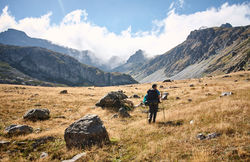
Hiking above the clouds along the ridge to the hill-side village of Hyder.
 |  |  |  |
|---|---|---|---|
 |  |  |  |
 |  |  |  |
 |  |  |  |
 |  |  |  |
 |  |  |  |
 |  |  |  |
 |  |  |  |
 |  |  |  |
 |  |  |  |
 |  |  |  |
 |  |  |  |
 |  |  |  |
 |  |  |  |
 |  |  |  |
 |  |  |  |
 |  |  |  |
 |  |  |  |
 |  |  |  |